
Logbook Entry 8 - Tuamotu Archipelago, French Polynesia
- Mar 26, 2018
- 8 min read

TOTAL MILES TRAVELED ON SAIL to SEE EXPEDITION: 8,147 (Nautical Miles)
THE LAST PASSAGE
Total Miles traveled on last passage:1,149 NM
Miles traveled using SAILS – WIND POWER ONLY: 848 NM
Miles traveled using both SAILS & ENGINES together: 235 NM
Miles traveled using ENGINES – FOSSIL FUELS ONLY: 66 NM
Ship Sightings: Several supply ships were sighted carrying food and supplies from Tahiti to the atolls
Animal Sightings in Pacific Ocean:
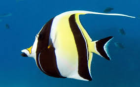
MARINE: Blacktip Reef Shark, Whitetip Reef Shark, Grey Shark, Spotted Eagle Ray, Lion Fish, Maori Wrasse, Moorish Idol, Butterfly Fish, Picasso Triggerfish, Trumpetfish, Cornetfish, Pufferfish, Squirrelfish
BIRDS: Black Noddy, Fairy Tern, Magnificent Frigatebird, Brown Booby,
LAND: Coconut Crab, Pigs
Photo Challenge: See if you can match each photo with one of the animals sighted on this leg!


VOS Reports Filed:
1 VOS weather reports was filed with NOAA on this passage through our satellite communications.
Average Air Temperature: 86.5 f/30.3 c
Average Sea Temperature: 83.3 f/28.5 c
Plastics Collection:
We deployed our plastics trawl one time in the Tuamotus and collected just a small amount of micro-plastics. The data was submitted to 5 Gyres for the world database.
PASSAGE NOTES:
We departed the Gambiers Islands for the Tuamotus Archipelago on a Friday afternoon. Normally, we consider it bad luck to depart for a passage on a Friday. This time we decided to tempt fate as we needed to start moving north and the wind was good for sailing. On our passage, we went by two islands that are off limits to visiting boats - Moruroa and Fangataufa. These islands were controversially used for nuclear weapons testing by the French. They may not be safe or healthy places to visit, even many years later.
Challenge question: What is the difference between an archipelago and an atoll?
Cultural sidenote - Maritime Superstitions
su·per·sti·tion
/so͞opərˈstiSH(ə)n/ - a widely held but unjustified belief in supernatural causation leading to certain consequences of an action or event, or a practice based on such a belief
Seafaring is one of the world's oldest occupations, so it is only natural that in times where unexplainable events have happened, superstitions have played a major role in providing reasons for their occurrence. Some common superstitions include:
No Bananas On Board - Aside from their peels causing many comedians to trip and fall down, bananas have long been thought to bring bad luck, especially on ships. At the height of the trading empire between Spain and the Caribbean in the 1700's, most cases of disappearing ships happened to be carrying a cargo of bananas at the time. Detective challenge: Try to find out at least THREE different theories for why bananas may actually have been a source of problems on ships!
No Whistling on Board - Mariners have long held the belief that whistling or singing into the wind will "whistle up a storm".
"Red sky at night, sailor's delight; red sky in the morning, sailors take warning" the old saying goes. A red sunset indicates a beautiful day to come, while a red sunrise indicates rain and bad weather.
Don't Sail On These Days - Thursdays, Fridays, the first Monday in April or the second Monday in August.
Avoid Gingers - People with red hair (AKA gingers) were thought to bring bad luck to a ship if you happened to encounter one before boarding. However, if you speak to the redhead before they get the chance to speak to you, you're saved.
Son of A Gun - Male children born on the ship were referred to as "son of a gun" because the most convenient place to give birth on deck (if you weren't too afraid of having a woman on board!) was on the gun deck. Having a male child on board was a sign of good luck.
The Tuamotus are extremely low islands surrounded by very dangerous coral reefs due to strong currents or water moving between the islands. It requires careful navigation to sail through them. We needed to check our position often to make sure we were in the right place and not sailing too close to the reefs. The passage took four days and three nights.

Our first stop was in Hao. The entrance into Hao was a narrow pass and there was current running against us. For a short time, it was like trying to sail up a river. We used the engines as well to have enough speed to get through the pass. Once inside the large lagoon, we found a wall to tie up to for a while. It was the first time we had been tied to a dock since Panama.


We walked into town. It was a holiday and most everything was closed though we enjoyed walking around and everyone was very friendly. On the atolls there are lots and lots of dogs and they are not always friendly though these three were.


Our next stop was Fakarava Island which took another two nights of sailing to reach. On the middle day of this sail, it poured down with rain so hard that we could not see very far. It was important to have the radar and electronic charts and GPS to check our position often and to watch for other boats. We did collect a lot of water to add to our tanks and to use for laundry and showers.
Fakarava has two passes. We entered in the south pass and then picked up a mooring. A mooring is like a permanent anchor made up of a line that is attached to the bottom. Moorings are good because they prevent the coral from being damaged by an anchor or anchor chain.
This is one of our favorite places because the diversity of coral and fish life is great - especially in the pass. We quickly got on our swimsuits and jumped in the dinghy with our masks and fins. We saw thousands of fish – and a lot of sharks too. There were three kinds of sharks – white-tip reef sharks, black-tip reef sharks, and grey sharks. They did not bother us but sometimes they came up to us for a closer look. The best thing we saw was a lot of healthy coral. It is like an underwater fantasy land full of different shapes and colors. We saw only a little bit of damaged, unhealthy coral. [More information below about unhealthy coral reefs and what people can do to help!]
Photo Challenge: Look at the pictures below to see if you can tell some differences between healthy and unhealthy coral.


We sailed up the inside of the lagoon watching the narrow strip of land go by. In some places, the land is only about 100 feet wide and not very high (elevation). The highest points of land are only about 6.6 feet/2 meters. The Tuamotus islands will have many problems with rising sea levels as they are so low. However, because the islands are so flat, many people ride bicycles everywhere which is better for the environment than motorized vehicles.


At the north end of the lagoon, we visited the small town of Rotoava. Here we bought some French baguettes and some fruit before sailing on to Toau.
At Toau, we did not enter the lagoon but we tucked into a spot that is open to the sea on the side of the atoll protected from the wind. We picked up a mooring here too. There was so much coral around us. We call the big coral sculptures “bommies”. The bommies just look like dark spots from Elcie’s deck but once you jump in with a mask, it turns into an amazing underwater world. We swam until we were all waterlogged. Again, we were so happy to see healthy corals and lots of fish and sharks.
On shore was a fishing camp and a family lived there. It is far from any towns so they have to be very self-sufficient, much like living on a boat. There is no freshwater on the atolls so they need to collect rainwater for cooking, drinking and bathing. We bought some lobsters from them to have with our dinner. They will use the money to buy

flour and sugar and other necessities the next time they make the long trip back to Fakarava with their small boat.
Check out this video about the Tuamotu Archipelago
...watch out for sharks!

We still had a two-night sail to Tahiti. Finally, we had no rain and very nice sailing. There was no moon so the nights were quite dark but very starry. During the day, we saw a French navy ship heading towards the Tuamotus. They did not show up on our AIS or ship identification system which we thought was very strange.
In Tahiti, we tied to a dock again. It felt odd to suddenly be in a city with tall buildings and traffic after so much time at small islands and at sea. We will enjoy walking to the shops and the fruit market and there is even a McDonalds so Emma and Molly are planning to go get some pommes frites. Can you guess what they are?
On the island next to Tahiti, we visited a Marine research facility that had an interesting project going on to restore the coral reefs around Moorea. We talked to Ken Nedimyer who is in charge of the project. With a lot of help from divers, artificial 'trees' are placed on the reef. Small pieces of live coral raised in tanks are placed on the 'trees'. The coral should grow and form around the trees to replace some of the corals that have been damaged or lost to environmental stresses or cyclones. Check out this youtube video about the project.

Emma was writing a research paper on coral reefs during this leg of our voyage. I am including part of her paper here because it has some great ideas about how we can all help coral reefs stay healthy and alive.
What can you do to protect coral reefs? There are a lot of small things one can do to protect coral reefs besides trying to combat climate change. For example, just being aware when snorkeling and diving is extremely important. Being careful not to kick over any coral and not damaging the reef in any way is vital. Also, not walking, touching, or taking any coral or other reef organisms helps keep the reef strong and healthy. It’s important to keep track of plastic trash and keep it from going into the water. Another way to protect coral reefs is to make sure the sunscreen you wear before going swimming is mineral-based and does not contain oxybenzone because it is believed to be causing coral deaths. Even though combatting climate change seems difficult, just doing simple things like riding bikes instead of driving and choosing to use clean energy instead of burning fossil fuels all help to reduce our carbon output. Volunteering to help at a beach cleanup is also helping protect coral reefs. If we cannot get the damage of the reefs to slow down we will need to try to find alternatives.
Until next time…thanks for following along on our voyage. Please send us any questions you might have. We would love to hear from you.
COUNTRY FACTS
Official Name: Tuamotu Archipelago, French Polynesia
Population: 16,000
Area: 345 Sq Miles / 885 Sq Km (about the size of Western Europe)
Main Town: each atoll will have one main center of commerce
Type of Government: semi-autonomous island group designated as an overseas country of France
Currency: French Pacific Franc
Language: Tuamotuan, French
Highest Point: 6.56 feet/2 meters
Climate: warm tropical
Economy: subsistence agriculture, pearl farming, tourism
Major Exports: black pearls
Natural Hazards: tsunami, cyclones, sea level rise, coral bleaching
Country Flag:

Interesting Facts:
1. Tuamotu means “distant islands”. The Tuamotus are a French Polynesian chain of almost 80 islands and atolls forming the largest chain of atolls in the world.
2. Black (or Tahitian) pearls are the major export of French Polynesia, at 55% of the country's annual exports of 20 million dollars. They come in a range of colors, but generally contain tones of green, pink, blue, silver and yellow. The darker color is the source of the name 'black pearl'. Black pearls are formed naturally when a piece of sand gets stuck in the body of a very specific type of oyster, the Tahitian black-lipped Pinctada margaritifera. These rare pearls are estimated to naturally occur in only 1 in every 10,000 oysters. Therefore it is actually illegal to dive for oysters for the sole purpose of discovering natural pearls, as it endangers the oyster species. Today’s black pearls are virtually always cultured or farmed.
Science Side Note: Read more about how black pearls get their coloration!


Comments