
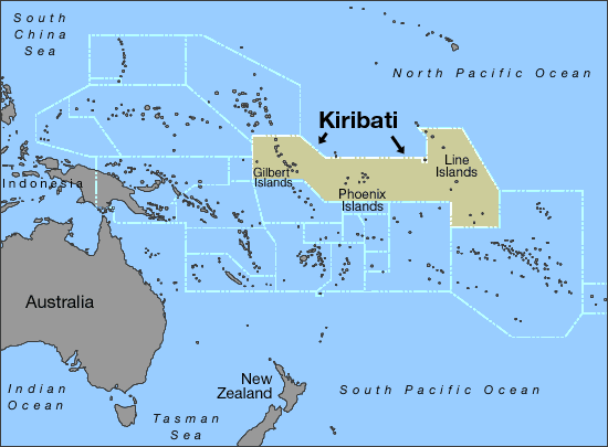
Logbook Entry 9 - Tahiti to Christmas Island, Kiribati
- Apr 16, 2018
- 8 min read
TOTAL MILES TRAVELED ON SAIL to SEE EXPEDITION: 9556 NM

THE LAST PASSAGE
Total Miles traveled on last passage – 1409 NM
Miles traveled using SAILS – WIND POWER ONLY: 1324 NM
Miles traveled using both SAILS & ENGINES together: 25 NM
Miles traveled using ENGINES – FOSSIL FUELS ONLY: 60 NM
Ship Sightings: 0 – We did not see any other ships on this leg.
Animal Sightings in Pacific Ocean: Dolphins, brown boobies, red footed boobies, tropicbirds, flying fish

(photo credit: Molly Johnson)
Science Sidenote: Red-footed Booby
These well known seabirds do not migrate, but live year-round in tropical and subtropical regions of the Atlantic, Pacific, and Indian Oceans. They often follow (and sometimes land on) boats. Red-footed boobies feed at sea, but nest on land, perching in trees and shrubs near the coast. These are the smallest of more than half a dozen booby species. Red-footed boobies are strong flyers and can travel up to 93 miles in search of food. They often hunt in large groups, and are nimble enough to snare flying fish from the air.
Boobies are well adapted for diving and feature long bills, lean and aerodynamic bodies, closeable nostrils, and long wings which they wrap around their bodies before entering the water. Red-footed boobies use these attributes to plunge-dive and capture fish that they spot from above with their sharp eyes. At night, they may dive for schooling squid that are visible because of their phosphorescence. Once in the water, the birds use their webbed feet to aid swimming.


VOS Reports Filed: -- 6 VOS weather reports were filed with NOAA on this passage through our satellite communications system.
Average Daytime Air Temperature: 83.3 f/ 28.5 c
Average Sea Temperature: 84.7 f/ 29.3 c
Strongest Wind: 19 Knots (knots are a wind measurement of nautical miles per hour)
Plastics Collection: 7 plastics trawls carried out for ½ hour each. We found plastics in all but two of the trawls. Here is a photo of what we collected.

You can see how tiny the plastic is. This is a big problem because tiny micro-plastics can be swallowed by fish and birds and it makes them sick. The micro-plastics result from larger plastics degrading in the sun and breaking down. The only way to solve this is try and keep plastics out of the ocean in the first place.
Please watch and share Elcie's new video about our beach clean-up in Suvarrow Atoll and the plastics we found.
There has been much in the news lately about the Great Pacific Garbage Patch. It is a giant patch of floating garbage, larger than Texas. You can read more about it here.

Challenge Question: Can you think of ways to keep more plastic from becoming a problem in our oceans?
PASSAGE NOTES:
Our leg started in Tahiti with many other sailboats in a marina next to a city. It finished at a small island in Kiribati where we were the only sailboat anchored.
We left Tahiti with our two new Australian crew and spent about ten days sailing through the Society Islands in French Polynesia.

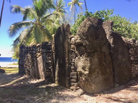
In these islands, we saw several archaeological sites that showed how Polynesian culture was a long time ago. In one area, stones were laid out to make fish traps that would force the fish into channels and then into a small round area where they could be caught. We also saw several Marae (Polynesian temple platforms or altars) that were used for government or ceremonial purposes.


Click here to watch three minutes of fish, fabulous scenery and fun!!! Emma's latest video from the Society Islands - and many thanks to Capt. Ron for the drone footage of Moorea.
After lots of exploring in the Society Islands, we finally set sail for Christmas Island, Kiribati. We estimated our trip would take around six days, which, if the sea is uneventful, can be a bit monotonous, so we planned a quick break in the trip to visit a nearby island called Malden.


Our knowledge of Malden was rather limited as all we knew was that it had been used for bird guano mining and then abandoned after hydrogen bomb testing’s several decades previously. Was Malden still abandoned? Was it safe for landing? And most importantly… Was there still danger from the bombings? Talk about an Elcie adventure!
Challenge Question: What is bird guano and why would people want to mine it? [Hint]
Historical Sidenote:
Malden Island, sometimes called Independence Island in the nineteenth century, is a low, arid, uninhabited atoll in the central Pacific Ocean, about 39 km2 (15 sq mi) in area. It is one of the Line Islands belonging to the Republic of Kiribati.
The island is best known for:
its "mysterious" prehistoric ruins - In 1924, the Malden ruins were examined by an archaeologist who concluded that they were the creation of a small Polynesian population which had resided there for perhaps several generations some centuries earlier
its once-extensive deposits of bird guano - although Malden was initially claimed by the U.S. Guano Company, the island was occupied and mined by an Australian company (1860s-1927) before the American company could begin operations
its former use as the site of the first British H-bomb tests (Operation Grapple, 1957)
its current importance as a protected area for breeding seabirds
Our first hints of getting close to Malden was a singular coconut tree sticking up from the horizon. Malden was the flattest island I had ever seen, three miles across and by the looks of it, just a couple meters high, if you don’t count the coconut tree, a couple shrubs, and the dilapidated buildings.

Geography Sidenote:
The island is very low, no more than 10 metres (33 ft) above sea level at its highest point. The highest elevations are found along a rim that closely follows the coastline. The interior forms a depression that is only a few meters above sea level in the western part and is below sea level (filled by the lagoon) in the east central part. Because of this topography, if you were standing anywhere on the island's low interior you would not be able to see the ocean!
As we got closer, downwind of the island, the strong smell of bird guano struck our noses. With the hundreds of birds soaring around as we sailed closer, it became evident that birds ruled this island, not man. Gannets, boobies, and frigates all meet in a single flock high over their island. Luckily, they seemed more interested in catching fish than us, so onwards we sailed.
Unfortunately, we found anchoring to be a challenge as we were met with very deep water and coral, so Jessica stayed out on Elcie while the rest of us hopped in the dinghy to go ashore. We landed on the sandy beach and from there, the crew split up to explore Malden. After a while, the smell of bird guano wasn’t too powerful and I got to appreciate the steady feeling of land under my feet. Looking around Malden, I felt like I had just walked into a very rundown area of the Great Plains. There were few trees, all surrounded by ankle high, yellowing grass. In the distance, I could see the lagoon of Malden, a mile or so away. Walking up to one of the shrubs, to my surprise, around fifteen birds flew up from the branches. Scattered on all the trees, there were bird nests. The inhabitants were all red footed and brown boobies, most of them full grown with a couple babies tucked precariously atop the nests.


We explored for a while longer, finding a grave yard, an over turned rail car and many bottles and junk from when Malden was inhabited during mining operations. Later we found out that the rail car would be loaded with bird guano (used for fertilizer) on the East side of the island. Richard and I also found scraps of bronze metal and planks of wood that we recognized from old ships that most likely wrecked on the reef surrounding the island. Unfortunately, after an hour, it was time to get back to the boat to keep heading towards Christmas Island. Looking back, the little excursion went very smoothly compared to some of our other adventures; everyone was safe and well! The crew had a quick swim and then up went the sails and Elcie was off again.


Engineering Sidenote:
The guano diggers constructed a unique railroad on Malden Island, with rail cars powered by large sails. Laborers pushed empty carts from the loading area up the tramway to the digging pits, where they were then loaded with guano. At the end of the day, the sails were unfurled, and the rail cars whisked back to the settlement by the prevailing southeastern winds. While cars were known to jump the tracks more than once during these excursions, the system seems to have worked fairly well. Railroad handcars were also used. This tramway remained in use on Malden as late as 1924, and its roadbed still exists on the island today.
We arrived in Kiribati in two days where we anchored in a harbor off Christmas Island. From Elcie, Christmas Island (also called Kiritimati Island) looked similar to Malden with its flatness but this island was much greener with tall bushes and many coconut trees. We were the only sailboat there. On shore, we could see kids playing basketball and several shabby concrete buildings. Our crew immediately went to shore and rented a car for the next day. While my sister and I did school, some of the Elcie crew took a tour of Christmas Island. They went through the towns London, Paris, Poland, and Banana. Banana was very traditional village with thatch houses on stilts, piles of coconut husks and pigs running around. Each village has a very large building called a Maneaba. It is used for town meetings, as a place to work in the shade and for community gatherings.


We stayed in Christmas Island for a couple days, enjoying the people and the (slow) internet. Our Australian crew left via the Christmas Island Airport a day later and then the next day, Elcie left too via the Pacific Ocean.
We will be back soon to report on our next adventures!
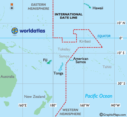
WHERE WE VISITED: CHRISTMAS ISLAND, KIRIBATI
Other Names: Kiritimati Island, Line Islands – Republic of Kiribati
Population: Entire Kiribati Population is 113,000
Population Density: 329 people per square mile
Land Area: 313 Sq Miles / 811 Sq Km in an area of the Pacific Ocean approximately the same size as the USA
Capital: Tarawa
Type of Government: sovereign democratic republic established in 1979
Currency: Australian Dollar
Language: English, I-Kiribati
Average Elevation: 6.5 Feet / 2 Meters
Climate: tropical marine, hot and humid, moderated by trade winds
Economy: small amount of tourism, agriculture and fishing
Major Exports: coconuts, seaweed, fish
Natural Hazards: typhoons, tornadoes
Country Flag: Kiribati flag homemade by Elcie crew

Interesting Facts:


1. Happy New Year!
Christmas Island is the first island to greet the new day as the island, while physically east of the International Date Line, is on the same side as the rest of the country for administrative purposes.
2. Christmas Island has the most amount of land area of any atoll in the world.

Geography Sidenote:
An atoll is a ring-shaped coral reef that encircles a lagoon (partially or completely). Most of the world's atolls are in the Pacific Ocean and Indian Oceans. The Atlantic Ocean has no large groups of atolls, other than eight atolls east of Nicaragua. The reef-building corals will thrive only in warm tropical and subtropical waters of oceans and seas.
3. What's in a name?
British and Dutch navigators first included the island on their charts from the early seventeenth century, and Captain William Mynors of the East India Ship Company vessel, the Royal Mary, named the island when he arrived on Christmas Day, 25th December, 1643. The four towns on Christmas Island are named London, Paris, Poland and Banana.
Comments