
Logbook Entry 23 - US Virgin Islands - Puerto Rico - Turks and Caicos
- Mar 31, 2019
- 7 min read

TOTAL MILES TRAVELED ON SAIL to SEE EXPEDITION: 30604
THE LAST PASSAGE
Total Miles traveled on last passage –668
Miles traveled using SAILS – WIND POWER ONLY: 300
Miles traveled using both SAILS & ENGINES together: 282
Miles traveled using ENGINES – FOSSIL FUELS ONLY: 86
Ship Sightings: many other sailing boats, container ships, ferries and fishing boats
Animal Sightings in Atlantic Ocean/ Caribbean Sea: lots of Coral and Fish, Sting Rays, Sea Turtles, Hermit Crabs, Humpback Whales, Dolphins, Booby Birds, Magnificent Frigates, Terns
Strongest Wind:18 Knots (knots are a wind measurement of Nautical Miles per hour)
PASSAGE NOTES:
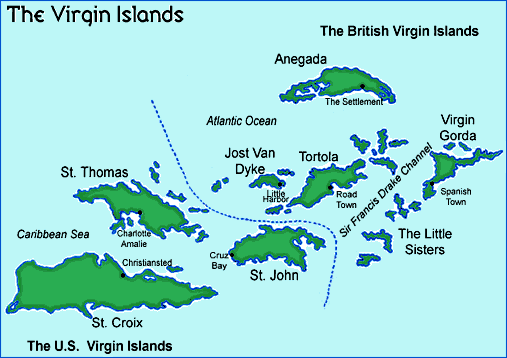
We started the last leg in the United States Virgin Islands. This group of islands in the Caribbean is a popular vacation spot for families. St. Thomas is also a cruise ship port and at least three giant cruise ships come and go every day. St. John is an island that is mostly a very large national park.


The day before our new crew joined Elcie, we stocked up on food and went to a dock to get diesel fuel. At the dock, we met a famous sailor named William Pinkney. Captain Pinkney was the first African American man from any country to sail solo around the world. He did his circumnavigation going east around the world which is a harder way to go than the way we have traveled. He is now 85 and he is still a captain of a sailboat that takes people on trips in the islands. We felt very honored to meet him.
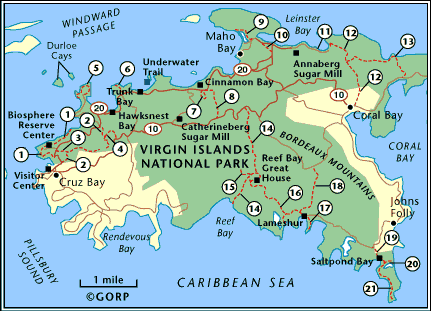
After our crew joined we traveled to St. John and enjoyed some hiking and snorkeling in the National Park. The next day we sailed to the British Virgin Islands and anchored at Jost Van Dyke, a small island with very friendly people.
All of these islands were badly damaged when two hurricanes, Irma and Maria passed over them within two weeks in 2017. The hurricanes brought damaging winds and high water to the islands. Many scientists believe that storms are getting stronger as the earth warms. This is not going to be good for the people that live on these islands in the hurricane belt. Many people lost homes and many roofs are still covered in blue tarps because they have not been fixed yet.


We sailed from the Virgin Islands to the island of Culebra which belongs to Puerto Rico. This is another island that is part of the United States. The people of Culebra speak Spanish. Culebra has a very large natural harbor that was once a base for the United States Navy. Now it is also a popular vacation spot, especially for Puerto Ricans who come here by ferry from the mainland.

In Culebra, we had an amazing opportunity to go out on a boat with a man who has learned how to listen to humpback whales. His name is Paul Knapp Jr and he uses a hydrophone which is a special microphone that works underwater. It picks up the sounds and songs of humpback whales that are migrating through the waters around Culebra at this time of year.


We traveled about a half hour in the boat before we stopped and drifted with the hydrophone in the water. Right away we heard sounds of several humpback whales. The whales were most likely a couple of miles away. Paul believes that the whales are speaking for the environment and that we should listen to their songs so that we will be inspired do more to protect the earth and our oceans. Watch this video for a taste of the wild whales we heard!
Also check out this great article about the connection between the science of whale songs, music, and activism.
From Culebra, we sailed to the city of San Juan on the mainland of Puerto Rico. Passing into the harbor of Old San Juan, we sailed by a fort called El Morro. The fort was built in the 16th Century to defend the city of San Juan against invaders.

In the evening, we walked around Old San Juan. Many of the houses in Old San Juan have fancy ironwork on them and are painted in very bright colors. Old tiles still decorate some of the walls and floors in the buildings. The cobblestone streets are made of blue stones that arrived in Puerto Rico as ballast on sailing ships coming from Spain.


From Old San Juan, we had a sail of 370 miles to reach Turks and Caicos. On this passage, we sailed close to a shallow bank called Silver Bank that attract humpback whales. It is an area where mother humpbacks give birth to and feed their calves. We saw one whale breaching and the spouts of several others. We were hoping to see more whales but we are a bit late in the season.

We arrived at South Caicos in Turks and Caicos after about fifty hours at sea. The winds were light and we had to motor for some of the trip. We don’t like to burn diesel fuel if we don’t have to. We would much rather use wind power to sail whenever we can. South Caicos is another place that was hit hard by the hurricanes. Cockburn Town is the capital of Turks and Caicos. It is not a big town and has very small houses, some very old. On the dock, a conch fisherman gave us a bag of conch meat that had just been caught that day. Two women were cleaning the conch that was in a large cooler. It looked like a very messy job. The conch fishery is important to the economy of Turks and Caicos.


We took our fresh conch meat back to Elcie and made conch fritters with it after cutting the meat into tiny pieces. Conch fritters are made with flour, baking powder, egg, seasoned salt, minced vegetables, spices and water. The conch pieces are stirred into it and then it is fried in a pot of very hot oil. It is served with a sauce made with mayonnaise, ketchup and lemon juice. Our conch fritters tasted very delicious.

The next day was Sunday and we spent much of the day sailing across a shallow sand bank to another island, Providenciales. The sand bank was many shades of turquoise and aqua and was only about 10 – 12 feet deep the whole way. We could see the shadow of Elcie’s sail on the sand bottom as we sailed across.

Sadly, we found some large chunks of styrofoam floating in this beautiful water. We used the kayak to pick up as much as we could. We wanted to collect it before it had a chance to break down into tiny micro-plastics.

Along the way, we made a big tray of cinnamon rolls to eat as a treat. We always enjoy baking homemade treats on Elcie when we can. Cinnamon rolls are fun to make and are also delicious.

On our last night in Sapodilla Bay, a few days after the full moon, we took the dinghy out at night to watch for glowing worms that send out bioluminescent lights as part of the mating process. They are called Odontosyllis enopia and look like underwater lightening bugs. We saw about twenty of them around the dinghy.


SCIENCE SIDEBAR
Every month after the full moon, a natural phenomenon lights up the ocean, creating the appearance of twinkling stars in the sea. But these flashes of light that shimmer just below the ocean surface are, in fact, the creation of life. It’s the mating dance of the Odontosyllis enopia—known locally as the glow worm, a bioluminescent marine worm—and it’s a remarkable light show you can’t miss if you’re in the Turks and Caicos at just the right time. The show begins three to five days after the full moon and almost an hour after sunset. That’s when the female glow worm rises from the sandy seafloor where she resides to the surface of the water, swimming in circles and releasing her eggs—all while emitting a bright fluorescent chemical that attracts her male counterpart. While swimming to his mate, attracted by her beckoning glow, the male worm also “glows” as he makes his way to his partner. He then releases his sperm, creating even more light. All this from these tiny marine worms, with the females growing to about 20 mm long, and the males growing only to 12 mm. The only way to witness the spectacle of the glow worm is to be out on the water particularly in shallow areas.
An exciting thing that happened on this leg is that the number of miles we have sailed on Elcie this trip passed 30,000 NM.

Our crew departed from Sapodilla Bay the next day. Our next stop is the Bahamas and then we will be back in the USA. Soon, we will finish our circumnavigation by returning to an island we visited at the start of our voyage. We’ll tell you more about that and more in our next logbook entry!
WHERE WE VISITED: TURKS AND Caicos Islands
Population: 31,458
The Population of Turks and Caicos shifted in the last 50 years. In 1950, Salt Cay had a population of over 500, while Providenciales had a population of less than 500. Today, less than 100 people reside on Salt Cay, whereas over 25,000 reside on Providenciales.
Challenge Question:
Why do you think the population may have declined on Salt Cay?
Area: 616.3 km2 (238.0 sq mi)
Main Town: Cockburn Town
Type of Government: Under constitutional monarchy of the UK. Fun Fact: Turks and Caicos once had a presidency (they have a premier today), but had to stop the practice due to excessive cost
Currency: US Dollar
Language: English, Turks and Caicos Islands Creole
Highest Point: Blue Hills are the highest point of Turks and Caicos Islands with an elevation of 161 ft. (49 meters).
Climate: The Turks and Caicos Islands feature tropical climate, with relatively consistent temperatures throughout the course of the year. Summertime temperatures rarely exceed 33 °C (91 °F) and winter nighttime temperatures rarely fall below 18 °C (64 °F).
Major Exports: salt industry, tourism, fish (mainly conch)
Natural Hazards: very dry land, frequent hurricanes.
Country Flag:

Interesting Facts:
The Turks and Caicos flag features three common elements from the islands: a conch shell, a spiny lobster and a Turks Head cactus.


The Turks and Caicos Islands have the third largest barrier reef system in the world and several of the world’s top dive sites.

Turks and Caicos has the largest above-ground cave system in the Caribbean. They are called the Conch Bar Caves and are on Middle Caicos.
The shallow waters around all the islands of Turks and Caicos led to over 1,000 shipwrecks during travel to and from the islands.
Comments